Vicar Street
Vicar Street is the R332, a regional road in Tuam, at the heart of the town. It runs 312 m from Sean Purcell Road to Dublin Road, about 4 minutes on foot end to end. It has 18 named places on the map: 2 pharmacies, 2 clothes shops, 2 pubs and bank and more.
- Type
- Regional road (R332)
- Length
- 312 m of mapped road
- From the Square
- On the Square
- Runs
- from Sean Purcell Road to Dublin Road
- Bus stops
- Tuam (Vicar Street Florist); Tuam (Vicar Street Bon Secours)
- Parking
- 3 car parks on the street: The Shambles Car Park, BoI Car Park and car park
- Density
- 18 named places over 312 m, 5.8 per 100 m
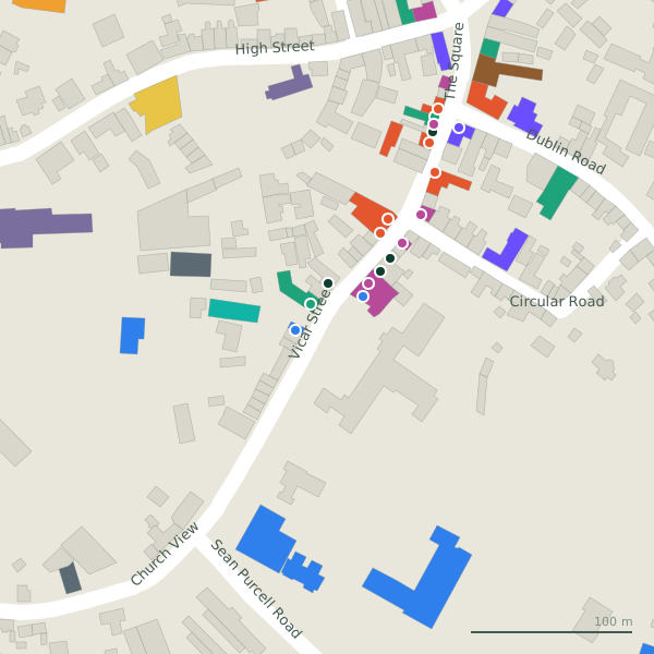
The street is drawn in black; buildings are coloured by what is in them. Drag to turn the model, tap a pin for the place.
Plan of the street
A walk along Vicar Street
Start at the Sean Purcell Road end and walk towards Dublin Road: 2 pharmacies, 2 clothes shops, 2 pubs, a bank, an electrical and a restaurant and more share the 312 m. Buses stop on the street itself at 2 stops. There is parking on the street: The Shambles Car Park, BoI Car Park and car park.
What is on Vicar Street
2 pharmacies, 2 clothes shops, 2 pubs, 1 banks and 1 electrical and more, each with its own page.
Restaurants · 5
- Golden PizzaRestaurants
- Spice of LifeDeli
- The Galway RoastCafés
Shops · 4
- One Step AheadHairdressers
- Pet HavenPet shops
- SAB FashionClothes shops
- Tiny ToesClothes shops
Pharmacies · 2
- Gleeson PharmacyPharmacies
- Kilgarriff's ChemistsPharmacies
Doctors · 2
- Tuam DentalDentists
Banks · 1
- AIBBanks
Other places · 4
- Expert ElectricalElectrical
- Off LicenceAlcohol
- R&B Locksmiths+353 93 24211Locksmith
- Tuam Book ShopVacant
Streets it joins
- Church Viewregional road · 1 place
- Circular Roadlink road · 1 place
- Dublin Roadregional road · 10 places
- Sean Purcell Roadregional road · 2 places
- The Squareregional road · 12 places
Questions people ask
Where is Vicar Street?
How long is Vicar Street?
What is on Vicar Street?
Is there a bus stop on Vicar Street?
Where can I park near Vicar Street?
Geometry, names and places from OpenStreetMap, read on 2026-09-18. Length is the sum of the mapped segments carrying this name; distances are straight lines from the street's midpoint.